← Back
Using Micro-Satellite Tags to Track Tiny Sea Turtles

Upwell works to better understand how sea turtles use different marine environments at various life history stages in order to reduce the threats they face at sea. However, collecting data on a turtle’s behavior in the middle of the ocean presents distinct challenges. Argos services help Upwell’s researchers and collaborators overcome these challenges and collect critical data.
Generating data on movements and habitat use is especially difficult for juvenile sea turtles because satellite tags (especially ones hardy enough to work in the ocean) far exceed the “golden rule” of being no more than 5% of the turtle’s weight.
This means that there is little knowledge about a hatchling’s life after it leaves the nesting beach, the period often referred to as the sea turtle “lost years.” One of Upwell’s most exciting projects, the Lost Years Initiative, is focused on understanding where and how juvenile turtles live during this vulnerable life phase.
To solve the mystery of the lost years, Upwell partnered with tag manufacturer Lotek Wireless, Inc. to develop micro-satellite tags small enough to follow juvenile turtles (100 grams and larger) out to sea.
Since 2021, Upwell has deployed various models of Lotek micro-satellite tags—the smallest one a mere 2.5 grams—on 224 juvenile turtles in collaboration with institutions engaged in sea turtle conservation around the world, including Florida Atlantic University Marine Lab, Okeanos Institute of the University of Azores, Two Oceans Aquarium, Cayman Turtle Centre and Phuket Marine Biological Center. Another essential collaborator is Mercator Ocean International, which works with Upwell to provide analysis and interpretation of the data collected.
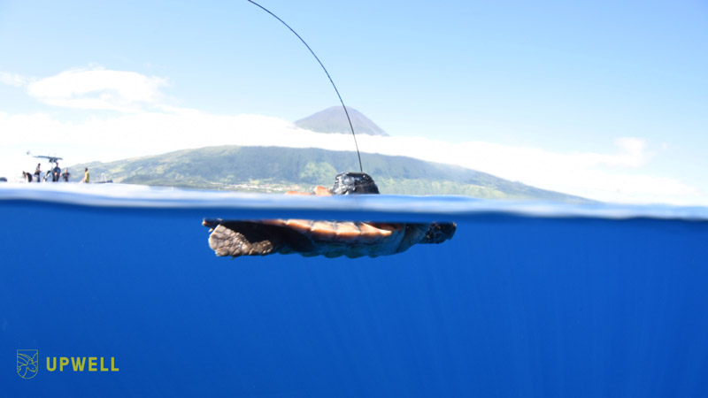
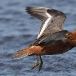
A juvenile loggerhead with a micro-satellite tag swims at the surface in the Azores Archipelago. The turtle was tagged and released in partnership with the COSTA Project and the University of the Azores. The photo was taken by Nuno Vasco Rodrigues
The Lotek micro-satellite tags utilize novel technology, materials, batteries, and transmission strategies in order to achieve the light weights and small “footprints” of the transmitters. The tags use a whip antenna to transmit to the satellites carrying Argos payloads only when the tag detects that the antenna is clear of the water via a saltwater switch (or wet–dry switch).
Depending on the expected dispersal area around the different turtle release sites, Upwell researchers estimated the satellite coverage hours from Argos website data and fitted the transmission schedule to those coverage hours for maximum optimization. This optimization of tag transmissions helped to enable the use of smaller batteries, which are often the largest and heaviest part of a satellite transmitter design.
Further miniaturization of the batteries was possible thanks to the Argos-3 network, which uses Convolutional encoding that offers a theoretical 3 dB gain through the transmission channel, which in turn means that transmit power can be halved for the same amount of data throughput and error rates.
Despite the challenges that come with miniaturization, the tags have performed satisfactorily, regularly providing accurate locations. Compared to typical Argos location errors (<250 m to ≅2 km), the location errors generated by the Lotek tags were relatively large but within an acceptable range given limitations such as low transmission current and power. Over 80% of the best daily locations fell within an error radius range of 2 km or less.
In the next two months, Kinéis will launch 25 nanosatellites carrying new generation IoT payloads for Argos services that will upgrade the constellation and improve efficiency and increase location qualities and overall data throughput. These advances are especially beneficial to Upwell’s biologging efforts with microsatellite tags, which have limited battery power and transmission capabilities relative to the larger satellite tags deployed on bigger animals.

Figure 5. Trajectories of loggerheads obtained from the Azores, superimposed with the bathymetry from General Bathymetric Chart of the Oceans (GEBCO) dataset [41]. (Candela et al. 2024).
The data collected so far already shows impressive insights, a team of scientists from Upwell and Florida Atlantic University observed that among dozens of individuals studied, several dove over 40 meters, including one to over 100 meters shortly after being released. As a group, those young animals spent more than 70 percent of their time underwater and made routine dives to beyond 70 meters (Shillinger, Pers. Commun. 2024).
An analysis of the performance of these micro-satellite tags and some of their collected data was recently published in Animals in a manuscript entitled “Novel Microsatellite Tags Hold Promise for Illuminating the Lost Years in Four Sea Turtle Species“. A study using data from these tags had previously been published (Barbour et al., 2023). These tracking experiments are also supplemented by numerical simulations providing complementary insights on juvenile sea turtles dispersal (Gaspar et al., 2022, Shillinger et al., 2012).
With further tag miniaturization, solar power enhancements to battery life, additional dive sensors, and improved data compression algorithms, Upwell aims to collect longer, more robust data on juvenile turtle movements and behaviors.
This data can then be used to support turtle conservation by highlighting potential “hatchling highways” deserving protection (e.g., by limiting fishing gear types, reducing vessel speed limits, prioritizing cleanup of pollution, etc.) and informing communities, resource managers, and governments how to make decisions that enable sea turtles to persist and thrive.
Reference & links
- Barbour, N., Bailey, H., Fagan, W. F., Mustin, W., Baboolal, V., Casella, F., Candela, T., Gaspar, P., Williamson, S., Turla, E., & Shillinger, G. L. (2023). Satellite Tracking of Head-Started Juvenile Green Turtles (Chelonia mydas) Reveals Release Effects and an Ontogenetic Shift. Animals, 13(7), 1218. https://doi.org/10.3390/ani13071218
- Candela, T., Wyneken, J., Leijen, P., Gaspar, P., Vandeperre, F., Norton, T., Mustin, W., Temple-Boyer, J., Turla, E., Barbour, N., Williamson, S., Guedes, R., Graça, G., Beltran, I., Batalha, J., Herguedas, A., Zailo, D., Baboolal, V., Casella, F., & Shillinger, G. L. (2024). Novel microsatellite tags hold promise for illuminating the lost years in four sea turtle species. MDPI. https://doi.org/10.3390/ani14060903
- Gaspar P, Candela T and Shillinger GL (2022) Dispersal of juvenile leatherback turtles from different Caribbean nesting beaches: A model study. Front. Mar. Sci. 9:959366.https://doi.org/10.3389/fmars.2022.959366
- Shillinger, G.L., Di Lorenzo, E., Luo, H., Bograd, S.J., Hazen, E.L., Bailey, H. and Spotila, J.R. (2012). On the dispersal of leatherback turtle hatchlings from Meso-American nesting beaches. Proceedings of the Royal Society B, 279: 2391-2395. https://doi.org/10.1098/rspb.2011.2348