← Back
Tracking Billfishes, the Ocean’s Fastest Predators, with Argos Services

Billfishes (swordfish, marlin, sailfish, and spearfish) are among the ocean’s most formidable predators, yet their movements have long been shrouded in mystery. Traditional tools like pop-up satellite archival tags (PSATs) have provided only rough estimates of their vast migrations. However, a new study led by Dr. Martin Arostegui at Woods Hole Oceanographic Institution shows that, thanks to advances in Argos satellite transmitter technology, researchers can now uncover their behaviors in far greater detail.
The Argos Advantage for Billfishes Tracking
Argos transmitters work by using Doppler-based signals to generate highly accurate, near real-time locations. While they’ve long been used on marine mammals and turtles, their application to fish has been limited because fish don’t need to surface to breathe. This study demonstrates that many billfish species actually do spend significant time near the surface, often more than 40%, especially at night. Even deep-diving species like swordfish occasionally rise to the surface, allowing Argos tags to transmit valuable data.
Innovative tag designs have also made a difference. The effectiveness of Argos tags depends not just on the fish’s behavior but also on the form and placement of the tags. Towed models with buoyant, upright designs have proven particularly promising. For instance, new Smart Position and Temperature (SPOT) tags that are smaller and more hydrodynamic than their predecessors enable tracking of even small-bodied billfish.

Case Studies: Revealing Hidden Behavior of Billfishes with Argos
In a compelling case from Hawaiian waters, a shortbill spearfish was tracked for nearly four months. Researchers found that the fish adjusted its swimming speed depending on ocean current direction and strength, saving energy when swimming with the current and speeding up against it.
This subtle yet crucial behavior came to light only through the precision of data obtained using Argos Services. The same track led to the naming of two undersea features, now known as the ‘Hebi Seamounts’, which the spearfish briefly visited.
Your Title Goes Here
Case study #1: current-oriented swimming. (a) Observed track of a shortbill spearfish with the daily vector components of surface current (light blue) and active swimming (yellow) overlaid on bathymetry. Deployment start (green upward triangle) and end (red downward triangle), initial 12-day period of the deployment with no Argos locations (dashed black line), and the state-space modeled track (solid black line) are indicated. (b) Mean active swimming velocity of a shortbill spearfish relative to surface current heading and velocity. The 0 ◦–180 ◦grid represents the absolute value of the difference between the headings of the fish and current, where 0 ◦, 90 ◦, and 180 ◦represent swimming with, perpendicular to, and against the current, respectively. (c) Example daily vector field of surface current with the spearfish’s collocated position (red point) and preceding 5 days of locations (red line), highlighting an instance of swimming along a contour of divergence prior to transiting with a following current to an area of convergence.
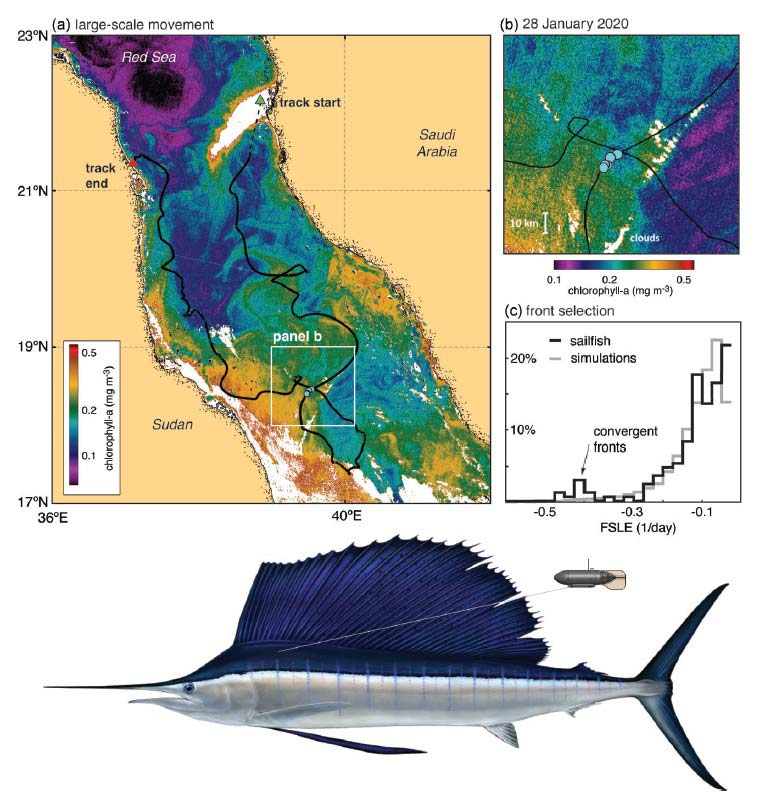
Another example from the Red Sea involved a sailfish tracked using a towed Argos transmitter. With a remarkable 87% of days yielding data and up to seven locations per day, researchers identified the fish’s interaction with submesoscale ocean features—small, nutrient-rich eddies and fronts just 1–10 km across.
These features are known to concentrate prey but have been virtually invisible in past billfish studies due to coarse data resolution from the PSATs typically used to study these species. Here, the sailfish was shown to selectively associate with such oceanographic hotspots, an insight with major ecological and conservation implications.
Your Title Goes Here
Case study #2: association with submesoscale features. (a) Near-surface chlorophyll-a concentration for 28 January 2020 overlaid with the track of a sailfish. Deployment start (green upward triangle) and end (red downward triangle), initial 5-day period of the deployment with no Argos locations (dashed black line), and the state-space modeled track (solid black line) are indicated. The large white region near the start of the track is a result of the Petro Rabigh refinery plume that pre v ents ocean color retrie v als. To remo v e this and other spurious features, all chloroph yll-a concentrations o v er 0.5 mg m −3 are masked. (b) Individual high-quality Argos locations (cyan dots) inside a low-chlorophyll submesoscale eddy. (c) Histogram of backward-in-time FSLE sampled along the track of the sailfish and 10 0 0 simulated tracks. Note the chlorophyll-a color bars differ between panels a and b.
A Tag Built for Billfish Tracking with Argos
To capitalize on this potential, the authors and Wildlife Computers (an animal telemetry company) developed the SPOT-413, a new-generation towed tag purpose-built for billfishes. In flume tests, this model showed dramatically reduced drag while maintaining surface transmission performance.
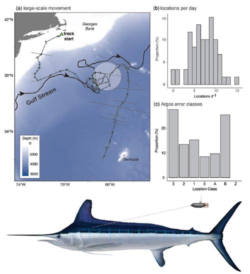
A real-world deployment on a white marlin in the Northwest Atlantic yielded excellent results, averaging seven high-quality locations per day over nearly two months. Its ability to resolve fine-scale movement patterns opens the door to research that was previously out of reach.
Your Title Goes Here
Case study #1: current-oriented swimming. (a) Observed track of a shortbill spearfish with the daily vector components of surface current (light blue) and active swimming (yellow) overlaid on bathymetry. Deployment start (green upward triangle) and end (red downward triangle), initial 12-day period of the deployment with no Argos locations (dashed black line), and the state-space modeled track (solid black line) are indicated. (b) Mean active swimming velocity of a shortbill spearfish relative to surface current heading and velocity. The 0 ◦–180 ◦grid represents the absolute value of the difference between the headings of the fish and current, where 0 ◦, 90 ◦, and 180 ◦represent swimming with, perpendicular to, and against the current, respectively. (c) Example daily vector field of surface current with the spearfish’s collocated position (red point) and preceding 5 days of locations (red line), highlighting an instance of swimming along a contour of divergence prior to transiting with a following current to an area of convergence.
Argos Services: Enabling the New Frontier of Marine Ecology
Behind these advances is the technology and infrastructure of Argos Services. By enabling near real-time, high-resolution tracking of billfishes and other pelagic species, Argos Services is transforming the way scientists study marine life. It allows researchers to move beyond broad migration paths and explore how ocean currents, temperature layers, and seafloor features influence behavior. Perhaps most importantly, this technology supports more effective conservation by identifying the precise habitats and movement corridors critical to species survival.
You can read the full article in ICES Journal of Marine Science, Volume 82, Issue 1, January 2025. Please reach out to the lead author of the study, Dr. Martin Arostegui from the Woods Hole Oceanographic Institution (email: martin.arostegui@whoi.edu), with questions or collaboration inquiries.