← Back
Seals Help in Assessing the Bathymetry Around Antarctica
")
Southern Ocean seals are frequently tracked marine animals. They thus provide a lot of environmental data on an otherwise poorly observed ocean.
This includes bathymetry of the Antarctica continental shelf, thanks to the recorded depths of their dives.
Measuring in situ sea bottom topography at high resolution is a tedious process at best – a ship must grid the area. Satellite altimetry enables to retrieve bathymetry at large scale, but needs in situ measurements to solve ambiguities, and lacks 2-D mapping capabilities.
When the sea is iced most of the year, things get complicated. The bathymetry of the Antarctic continental shelf is thus poorly known, while seafloor topography influences glacier flow rates and hence loss of ice from the continent.
Seals as validators of bathymetry
A large number of seals living around Antarctica have been equipped with Argos PTTs with temperature/depth sensors (also salinity and fluorometry sensors).
These seal observations are already integrated in multi-sensor in situ data centers, along with automated instruments such as Argo floats (see e.g., Elephant seals diving for science, Olive Ridley turtles help in ocean climate forecasting, Data collected from animals can help ocean observing systems) and used for ocean dynamics or biological studies.
More info about animal tracking with Argos
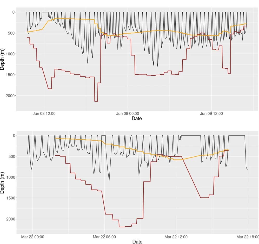
Dive depths, however, can also benefit bathymetry knowledge. It is hard to know whether a animal dived down to the very bottom, of course.
But if, at a given location, the pressure sensor shows that the dive is deeper than the local estimated bathymetry, this latter is probably wrong (taking into account the uncertainties on the dive lowest point location with respect to the surface location provided by Argos, and on this surface location).
A canyon discovered, depths re-evaluated around East Antarctica thanks to the seals
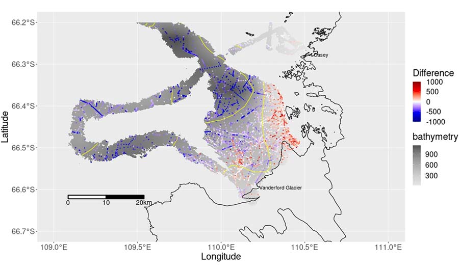
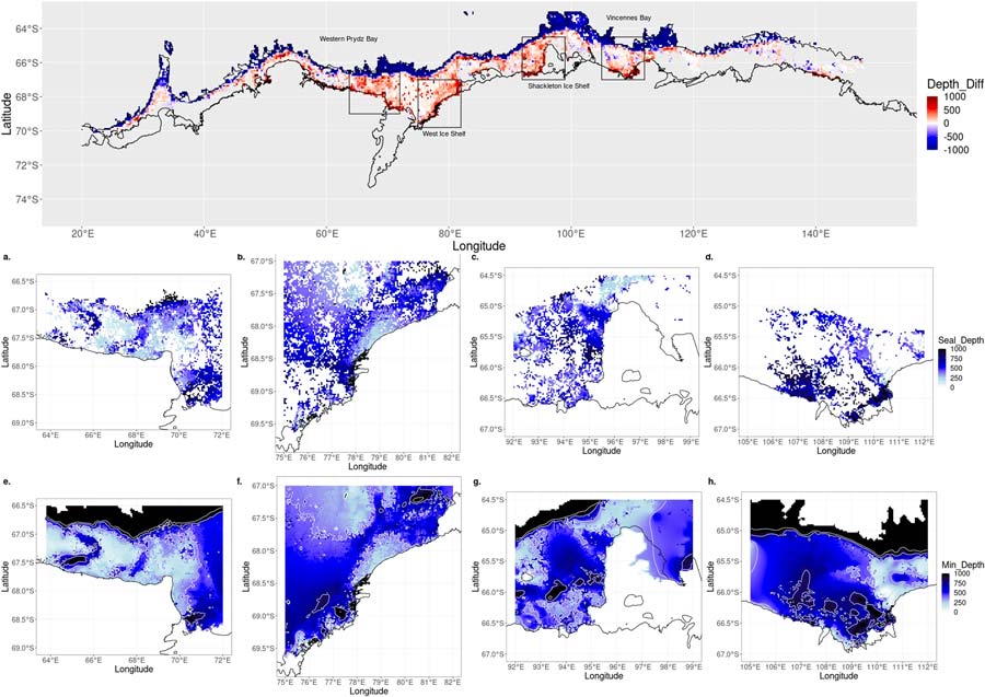
Dive data from 25 southern elephant seals tracked in 2012 in front of the Vanderford Glacier in Vincennes Bay (66.55° S, 110.25° E – south of the Australian west coast) were used to confirm the interest of those data in bathymetry validation. Among the 4089 seal dive profiles analysed, a third recorded depths deeper than the bathymetry datasets.
A high-resolution multi-beam survey of the region in 2022 showed the presence of a deep submarine canyon, probably missed by bathymetry datasets due to interpolation between sparse measurements.
The idea was then applied on a broader scale to the East Antarctic continental shelf between 20°E and 160°E. Data from 265 individual seals (50 Weddell seals and 215 southern elephant seals), provided a total of 557,874 dive records. A quarter of those on the area identified as continental shelf by the IBCSO V2 bathymetry dataset (i.e. water shallower than 2500 m) were deeper than the bathymetry.
The greatest discrepancies (some values being more than 1000 m) between the seal dive depth and the bathymetry dataset were along the coastal margins. Around the West Ice Shelf, 60% of 2.5 km x2.5 km cells contained dives deeper than the bathymetry (mean depth discrepancy about 100 m)
A new coastal bathymetry including seal-depth data
An ”hybrid” bathymetry was computed, using the maximum dive depths recorded as minimum depth of the ocean at each 2.5 km x2.5 km cell wherever the seals dived deeper than the bathymetry dataset deems possible. A future work on this could be to down-weight the seal dive maximum depths relative to higher precision observations, to take into account the uncertainty of the seal location estimates and depths relative to the true seafloor.
Moreover, the areas where seal dives and existing bathymetric products mismatch could be targeted for multi-beam survey campaigns, so as to measure high-resolution and high-precision bathymetry in priority over those regions, since the current estimates are definitely too low there.
Reference & links
- McMahon, C.R., Hindell, M.A., Charrassin, J.B. et al. Southern Ocean pinnipeds provide bathymetric insights on the East Antarctic continental shelf. Commun Earth Environ 4, 266 (2023). https://doi.org/10.1038/s43247-023-00928-w
- https://www.meop.net/