← Back
Polar bears tracked for more than 30 years in the Beaufort Sea
")
Polar bear’s foraging success is dependent on the presence of sea ice. Arctic sea ice, however, is rapidly decreasing in extent and thickness, and summer open-water periods are lengthening. As polar bears in the southern Beaufort Sea have been tracked using satellite telemetry for more than 30 years, a new study shows how they have modified their movements and distribution.
The polar bear’s (Ursus maritimus) Arctic sea ice habitat is rapidly changing from climate warming. For example, the area including the southern Beaufort Sea saw the ice-cover period shorten by 17.5 days per decade over 1979-2014. Polar bears rely on sea ice for hunting seals, but pack ice is fragmenting and disappearing. Sea ice breakup in spring is occurring earlier and freeze-up in fall is occurring later, leading to more extensive and longer open water periods in summer and fall (see Argos sheds light on polar bears’ changing summer habits).
All this may disrupt polar bear movements, mating, and foraging. Indeed, in recent decades, two different strategies have been observed among southern Beaufort Sea polar bears: coming on land in the summer or following the ice edge northwards and summering on the pack ice over the deep and unproductive waters of the Arctic Ocean.
Polar bear home ranges
An animal’s home range is the area where it moves and lives. It includes the resources it needs for survival, and for reproduction. A home range can be estimated using satellite telemetry locations, The home ranges enable an estimate of a number of important things for a species’ protection (see Jaguars in need of increasing biosphere reserve or Franciscana dolphins are staying close to home), including how home ranges may vary seasonally or regionally. If home ranges can be computed over a long enough period for enough individuals, it can identify changes in a species’ or population’s habitat use and distribution over time.
Polar bear home ranges have been shown to be larger than the ranges of similar land-bound carnivores. Their extent can differ among regions of the Arctic, from less than 20 thousand km² in Kane Basin (between Northern Greenland and Canada) to more than 350 thousand km2 in Western Hudson Bay.
A long history of polar bear tracking
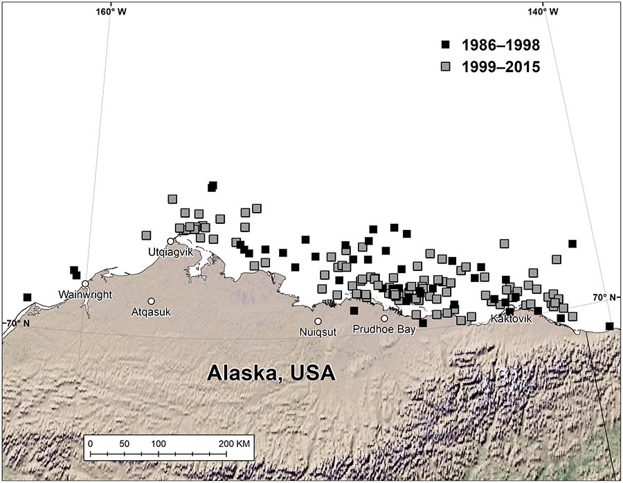
The United States Geological Survey (USGS) has a dataset of polar bear satellite locations from 1985 onwards over the Alaska portion of the Southern Beaufort Sea. From this database, the locations from 132 free-ranging female polar bears between 1986 and 2016 were extracted to compute their home range.
One of the requirements was to have at least one nearly full year of tracking (342 days minimum) with less than two consecutive weeks of missing data, except when in a maternal den. Male polar bears were excluded from this analysis because they were not collared: their neck is larger than their head, so they can’t retain a collar. A sea ice drift corrected set of locations was also prepared to separate the voluntary part of the movements of the polar bears from movements caused by ice drift.
A total of 187 annual and seasonal utilization distributions (UDs) were estimated from those 132 bears. The utilization distribution represents a probability density function of an animal’s geographic distribution over time and can be used as a representation of an individual’s home range. The mean locations of the annual and seasonal utilization distributions (i.e., the mean centroid of the utilization distributions) was also computed. Moreover, whether a polar bear summered on land or on sea ice was also evaluated.
Changes in polar bear home ranges in the southern Beaufort Sea
Between 1986–1998 and 1999–2016, a significant decline in sea ice occurred throughout the Arctic. In the southern Beaufort Sea, the average sea ice edge in September was about 200 km farther north in 1997–2010 relative to 1979–1996.
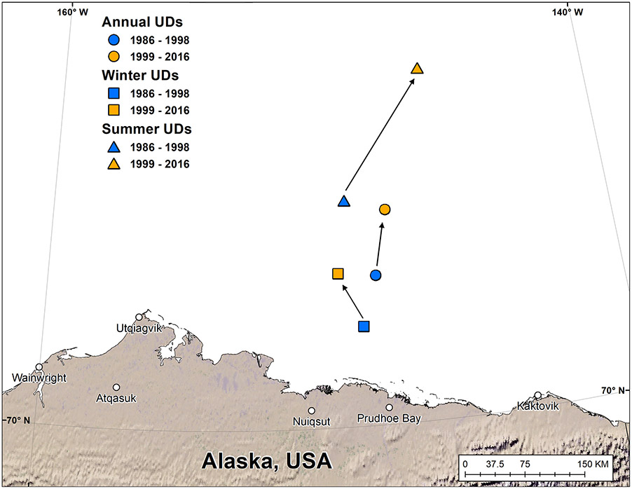
Analysis of the home ranges shows that, on average, the Southern Beaufort Sea polar bears which summered on land in 1999–2016 had home ranges that were 88% smaller than the home ranges of bears summering on pack ice. Home ranges of bears on the sea ice increased by 64% between 1986-1998 and 1999-2016, and the mean centroid of these home ranges shifted 85 km northward from where the mean home range centroid was in 1986-1998.
In the southern Beaufort Sea, polar bears have changed their use of space with the increase of open water and sea ice fragmentation. Polar bears that summer on land appear to expend less energy because they travel little on land and forage on beach-cast or hunter-killed marine mammal carcasses. In the meanwhile, those on sea ice likely expend more energy as they move further and more frequently, and have fewer prey available under the deep-water pack ice. In the future, the potential energetic advantage of land use might lead more polar bears to summer on land as sea ice loss continues.
Reference
Pagano, A.M., G.M. Durner, T.C. Atwood, D.C. Douglas, 2021: Effects of sea ice decline and summer land use on polar bear home range size in the Beaufort Sea, Ecosphere 12( 10):e03768., https://doi.org/10.1002/ecs2.3768
Main Photo: a polar bear with a satellite telemetry collar (credit: A. Pagano, U.S. Geological Survey)