← Back
Understanding Penguin Populations on the Antarctic Peninsula

The Commission for the Conservation of Antarctic Marine Living Resources (CCAMLR) was established by international convention in 1982 with the objective of conserving Antarctic marine life.
The CCAMLR Ecosystem Monitoring Program (CEMP) was established to detect changes in the krill-based ecosystems, providing a basis for regulating harvesting of Antarctic living marine resources in accordance with the ‘ecosystem approach’.
Argos satellite tracking is one of the tools used within this project to understand conditions of penguin populations living on the Antartic peninsula.
![]()
Argos tracking in the Antarctic peninsula
One of the projects thus funded is a collaboration between Argentina, Poland, Ukraine and the USA to track Adélie, chinstrap and gentoo penguins from 9 colonies on the Antarctic Peninsula.
The project examines the at-sea distribution of penguins from multiple breeding colonies in the South Shetland Islands and along the western Antarctic Peninsula at the end of the breeding season. Argos satellite tags were attached to 150 adults and recently fledged penguin chicks to track the dispersal from their colonies during winter.
More info about birds tracking
Project objectives
The project makes it possible for scientists to identify important winter habitats for the penguins and to quantify the overlap between these penguins, all of which feed on Antarctic krill, and the krill fishery in the Antarctic Peninsula during the winter.
This is crucial for the ecosystem-based management and for ongoing work on the design of marine protected areas (MPAs).
News from the field
Although the data analysis is not yet complete, what is clear is that Adelie and chinstrap penguins that breed on the Antarctic Peninsula disperse over a very large area of the Southern Ocean.
Long distance travellers
The furthest west achieved was 171W, by an adult chinstrap penguin, more than 5,000km from its release location in the Gerlache Strait. It got there about 5 months after tagging.
The nearest point of land for this traveller was Cape Adare on the northwest coast of the Ross Sea, roughly 1100km to the SW.
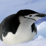
A chinstrap penguin on the Antarctica peninsula. Photo © Malgorzata Korczak Abshire
The furthest south achieved in this study was 69S by an Adelie fledgling in April, where it encountered water temperatures of -0.4C and was just north of the ice edge in the Weddell Sea at the time.
The furthest east achieved in this study was -23W by an Adelie fledgling in March, where it encountered water temperatures of 0.4C. It’s nearest land was Thule Island (the southern-most island in the South Sandwich Islands), some 400km to the NW.
The furthest north achieved in this study was -54S by a fledgling chinstrap, where it encountered water temperatures of 1.6C. The nearest land was Zavadoski Island (the northern most island in the South Sandwich Islands), some 250km to the SW.
These data help to understand the conditions that these penguins experience throughout the year and how these different conditions are likely to impact the populations overall.
![A tagged walrus in water (from [Solovyova et al., 2023]).](https://www.argos-system.org/wp-content/uploads/2024/02/tagged-walrus-in-water-150x150.jpg)