← Back
Ocean data to better understand marine animals in their environment

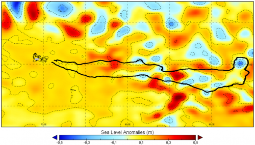
Argos satellite tracking makes it possible to follow the paths of tagged animals. This tracking data is invaluable, but sometimes it raises more questions than it answers. Why is the animal making a detour – or even a loop? Does it stay here or there for feeding, or for another reason? If it turns back, could it be due to water temperature?… Over the longer term, comparing tracking data with ocean data can help biologists understand the behavior of the tracked species, and ultimately contribute to their protection.
Below, Argos tracks of one young male elephant seal followed by IMOS, are overlaid on SST (top) and Chlorophyll-A (bottom) maps.
Ocean data on ArgosWeb
Argos users can benefit from CLS’ 20 years of experience in satellite oceanographic data processing and access state-of-the-art metocean data (such as Sea surface temperature, Phytoplankton, Primary production, Surface current, Surface wind, Clouds, Ice Cover and Sea Level Anomaly) directly via the ArgosWeb interface. For more information, or to subscribe to the METOC service, contact your user office.
More info about marine animals tracking
Some interesting studies combining Argos & ocean data
Please find a selection of articles from the web featuring combined ocean data and animal tracking studies:
Aviso Image of the Month, Feb. 2019: Sharks in eddies and meanders
Aviso Image of the Month, Jul. 2016: Elephant seals and macaroni penguins follow threads
Aviso Image of the Month, Dec. 2015: Multi-year penguin tracking
DUACS web site applications: Elephant seals turn around eddies
Argonautica case studies: Loggerhead turtles Bambi and Antioche
Aviso Image of the Month, June 2010: Penguins at large
Aviso Image of the Month, Sep. 2009: Birds track ocean eddies
Aviso Image of the Month, Mar. 2006: A long way to paddle home for a green turtle
Aviso Image of the Month, Jul. 2004: Leartherback turtles round eddies
