← Back
Turtles in a Hurricane
")
Turtles in the Gulf of Mexico experience major hurricanes. How they respond to such extreme events is a puzzle whose answers would contribute to the conservation of these threatened and endangered species. Telemetry provides some pieces to that puzzle.
On October 10, 2018, Hurricane Michael made landfall on Florida’s northwest coast. This tropical storm was classified as a Category 5 storm. Maximum winds were greater than 140 kts (260 km/h), which made Hurricane Michael the third most intense storm to make landfall in the United States.
One of the regionshit most often by hurricanes in the U.S. lies along the coast of Mississippi, Alabama and Northwest Florida. That area receives about one-third of the direct hits from those storms. The northern Gulf of Mexico is also home to threatened and endangered marine, coastal and aquatic species. Understanding how these species fare during such a hurricane, and what resources are required for them to survive such storm is critical in helping their populations recover.
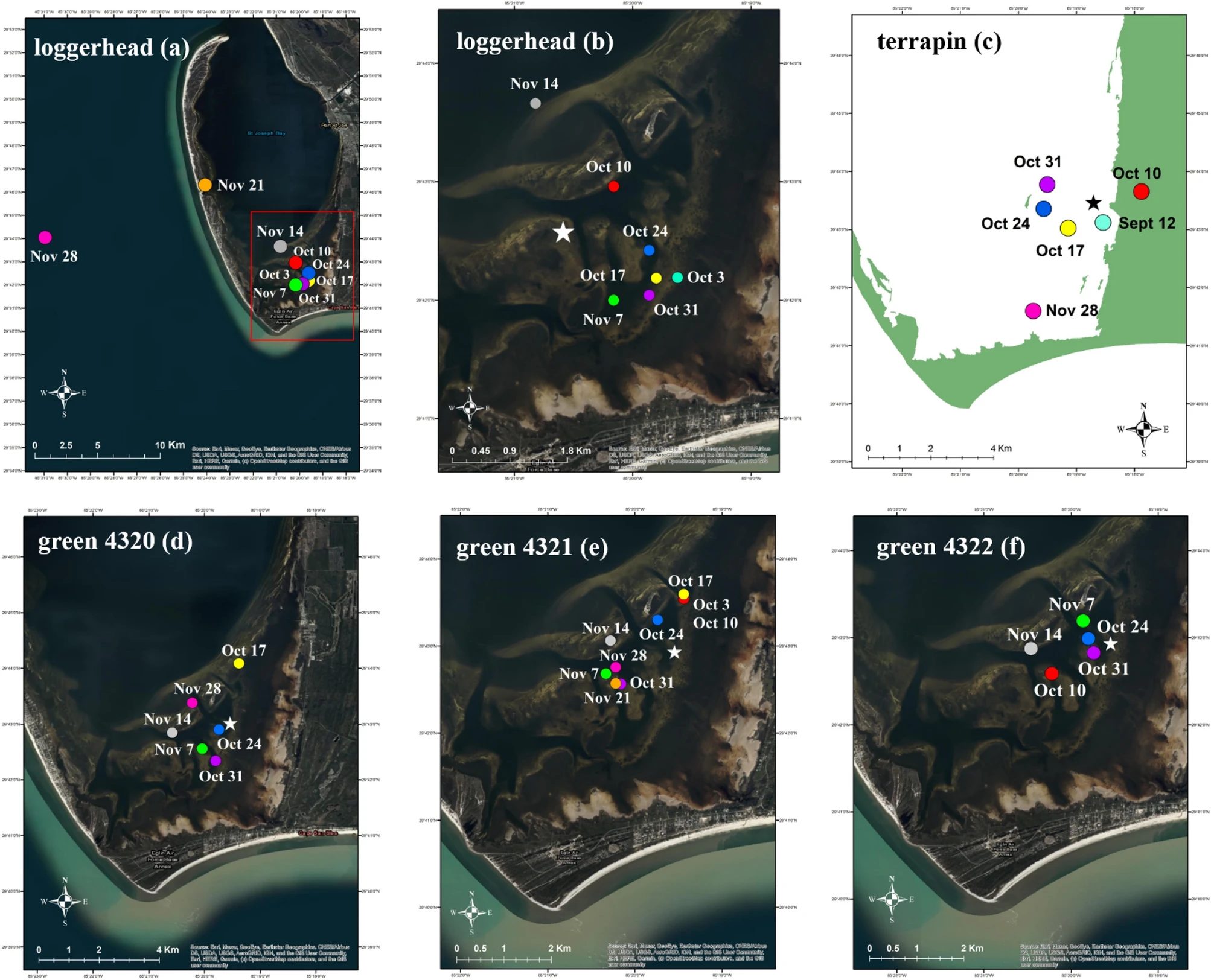
Six turtles tracked during a hurricane
Several species of turtles are found in the northern Gulf of Mexico, all are considered as imperiled (from vulnerable to critically endangered).
Fortuitously, several individual turtles inhabiting a coastal bay in northwest Florida were equipped with telemetry tags (satellite or acoustic) at the time of Hurricane Michael’s landfall. One loggerhead sea turtle (Caretta caretta), one Kemp’s ridley sea turtle (Lepidochelys kempii), three green sea turtles (Chelonia mydas – see [Lamont et al., 2023] for a recent study on this species in the Gulf of Mexico) and one diamondback terrapin (Malaclemys terrapin – see Lamont et al. 2021 for more information on this species) were tracked and localized in a coastal bay less than 30 km from hurricane landfall.
This was an opportunity to study turtles’ response to extreme weather in a coastal environment (while some studies were done in the open ocean, see Sea turtles in tropical cyclones).
More info about animal tracking with Argos
Analysis of the locations
Tags on 5 of the 6 turtles continued transmissions after the storm.
First of all, this confirmed the survival of (at least) 5 turtles. The cessation in transmissions from the Kemp’s ridley tag, 5 hours after landfall, could indicate mortality or tag damage. The first post-storm transmission from the other tags was detected from 6 to 47 hours after landfall.
In the few days before the storm and in those days immediately following hurricane landfall, no obvious large-scale movement nor change in behavior was detected from most of the tracked individuals. The loggerhead turtle used a large home range in the week after the storm which may have reflected changes in foraging effort immediately post-storm.
Long-term effects of Hurricane Michael on Northwest Florida habitats are still unknown and as such, impacts to turtles may still arise. A larger sample is needed to better assess turtles’ responses to major storm events in the coastal environment.
References & Link
- Lamont, M.M., A.M. Benscoter, K.M. Hart, 2023, Green turtle movements in the Gulf of Mexico: Tracking reveals new migration corridor and habitat use suggestive of MPA expansion, Global Ecol. Conserv., 42, e02380, 2023. Access here
- Lamont, M.M. , D. Johnson, D.J. Catizone, 2021, Movements of marine and estuarine turtles during Hurricane Michael. Sci Rep 11, 1577, 2021. Access here
- Lamont, M.M. Johnson, D., Catizone, D.J., 2021, Home ranges and movements of two diamondback terrapins (Malaclemys terrapin macrospilota) in Northwest Florida: Estuaries and Coasts, https://doi.org/10.1007/s12237-020-00892-0.
- https://www.usgs.gov/staff-profiles/margaret-lamont#science