← Back
Argos Data Provides Shocking Evidence to Legitimize Marine Protected Areas

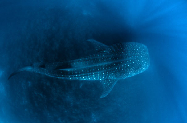
Since 1978 the ARGOS System has been used to improve scientists’ knowledge regarding animal behavior. However, Whale Sharks remain one of the biggest mysteries of the Oceans but thanks to technology we are discovering more and more.
Jonathan Green, Founder & Director of the Galapagos Whale Shark project, is a science graduate of the University of North London and has been working for nearly 30 years in the Galapagos Islands. The Galapagos Whale Shark Project (GWSP) is, in their own words, “a small group of scientists and volunteers whose common interests are the marine environment, diving and conservation. All have been inspired by Whale Sharks”.
“I think we now have the data that we need to be able to go to Government Institutions at a very high level and show the data that demonstrates exactly why we need to protect this area.”, Jonathan Green
This year, for the first time, a Whale Shark, now named Coco, surprised the team when she went directly from the Galapagos to the Isla de Coco in Costa Rica.
This is indeed exciting news as Argos data has now given the tools needed to lobby for protected areas. The data collected is irrefutable proof that Whale sharks, among other species, are feeding and breeding in particular areas and as such need to be protected.
Jonathan was kind enough to talk about how his satellite tagging projects have enabled his team to discover other exciting things about these curious creatures.
How it started
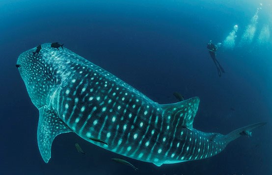
Jonathan’s first whale shark sighting was in 1990 at the Arch of Darwin. The more he began to learn about this species through diving, the more he realized how little is known about the species. This is where he came up with the idea of a project to begin tagging several Whale sharks.
The GWSP is a clear example of international cooperation. Current partners include Galapagos National Park, Marine Megafauna Foundation, Galapagos Conservation Trust, Georgia Aquarium, Fundacion Megafauna Marina del Ecuador, Galapagos Science Center and Planeterra.
Learning more through satellite tracking
Despite the lack of knowledge regarding these beautiful, living dinosaurs one thing we know for certain is that they are currently listed as Endangered.
While these gentle giants are rarely victim to natural predators, their numbers and behavior have been impacted by human activity such as Oil & gas drilling, Fishing and recreational activities.
The GWSP have been using ARGOS satellite tags since 2011 to try to uncover some of the mysteries surrounding Whale Sharks but it hasn’t always been easy…
Tagging challenges
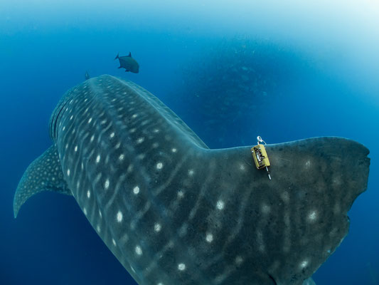
Whale sharks can measure up to 20 meters in length and have very thick skin, so there was a learning process when it came to tagging. Jonathan mentioned that the fin mounted clip has made the process a lot easier, “Perhaps one of the easiest things now is the satellite tagging because it’s a clip which is placed on the dorsal and the Whale shark swims away, usually not even realizing that they’ve been tagged”.
While technology has made tagging that much easier, there are still challenges faced when tracking Whale sharks.
Whale Sharks are known to be deep divers, satellite tags can currently withstand pressure down to 2000m. It became clear, very rapidly, that they were diving through that barrier and the team would then lose sight of the Whale shark. Currently, there are amazing tools to capture surface data but technology isn’t yet able to compete with these expert diving champions. Despite these challenges, some amazing things have been discovered.
Exciting discoveries
“It’s like taking somebody who can’t see and giving them sight”, Jonathan Green
Over the 10 years that the team have been using ARGOS, there have been many what Jonathan calls “Eureka” moments. One moment came when Jonathan used his background in Geology to look at the Argos tracks specifically in relation to benthic features, fractures, fissures and the Glaucus Riff system. What he found is remarkable, “…They are using the edge of plates as a virtual map for navigation so you can see that a whale shark will be heading northwards or southwards. It’ll meet a fissure which is going at a 90-degree angle and it literally takes a left or right-hand turn at that point. So, the Argos data was showing us very clearly that the Whale Sharks are using these Benthic Sea floor features for navigation and that’s probably how they are finding their way around the globe…”.
So what’s next for The Galapagos Whale Shark Project?
The future
“All life on earth came from the Oceans and if we don’t take care of it and life in the oceans is extinguished, life on Earth will follow”, Jonathan Green
While more is known thanks to these studies, there are still some burning questions that remain unanswered. Contrary to what was previously thought, Whale Sharks actually only stay in Galapagos for 24-72 hours.
So, Why do they come to the Galapagos if they don’t stay?
Thanks to their latest tagging project, the team are hoping to find out why a group of around 1500 female Whale Sharks are coming to Galapagos specifically.
Let’s hope we’ll be able to find out soon.


![A tagged walrus in water (from [Solovyova et al., 2023]).](https://www.argos-system.org/wp-content/uploads/2024/02/tagged-walrus-in-water-150x150.jpg)