← Back
Albatrosses Detect Illegal Fishing Boats

Albatrosses tend to be attracted by fishing boats, which is one of the main threats on the species. The bycatch risk is usually assessed by comparing albatrosses’ and (legal) boats locations. Illegal fishing grounds are less easy to pinpoint, though, except that the boats keep their radar on, an emission which can be detected if albatrosses are fitted with the right devices. The Ocean Sentinel project from CEBC/CNRS tested this with promising results
Location of fishing vessels: a key information for marine wildlife protection
Where are the fishing floats? The answer to this question is not an easy one. If a number of regulations, especially in the Exclusive Economic Zones of each country, tend to impose location systems on every fishing vessel (Vessel Monitoring Systems, VMS), they can be switched off, and international waters are not subject to such regulations. For now, the assessment of bycatch risks for wildlife (as described e.g. in “Argos helps in assessing fisheries bycatch risks to seabirds”) is based on voluntary declaration using Vessel Monitoring Systems (VMSs) or indirectly through the use of Automatic Identification Systems (AISs)mostly, but with the certainty of missing at least the illegal part of fishing efforts.
Developing a new tag
If the ships can switch off their Automatic Identification System, they are keeping their radar on for safety reasons, especially in an area like the Southern Ocean with noticeable risks of encountering an iceberg, or other vessels.
So, if those radar emissions can be detected by a geolocated device, the ship will be located. CEBC has developed with Sextant Technology a logger (XGPS) which provides the global positioning system (GPS) location of the mobile fitted with it and which detects radar emissions. Adding a GPS antenna, a processor and memory, an Argos antenna for real-time data transmission, a battery and a solar panel able to charge it, two versions of a platform were tested (Centurion and XArgos), weighting respectively 65 and 55 g. The difference is an internal archive memory which needs to be retrieved to be uploaded for XGPS, or a real-time retrieval of the data through Argos.
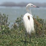
The albatross, Ocean Sentinel
Albatrosses are among the species often bycaught by fishing vessels in the Southern Ocean, since they tend to be attracted by the fishing boats from up to 30 km away (especially adult individuals) and can try to catch the baits or the fish taken on the long lines. They also are large seabirds (6-12 kg) which roam the full extent of the Southern Ocean, able to make a full tour of the Earth at latitudes of 30 – 70°S in less than 2 months.
For those reasons, fitting some of them with the new devices seems a good test of the concept.
Six-month testing
169 wandering (Diomedea exulans) and Amsterdam (Diomedea amsterdamensis) albatrosses were equipped on Crozet, Kerguelen or Amsterdam Island with one of the two platforms, depending if they were in breeding period (and thus returning to their nesting island regularly) or not (in the case or juveniles and non breeding adults).
During that period, the GPS locations whenever radar emission were detected by the birds’ platforms were compared with AIS/VMS locations – or with their absence. 632,333 GPS locations of albatrosses were retrieved, together with 5,108 radar detections, representing interactions with 353 different boats. The birds covered together an area of more than 47 million km2.
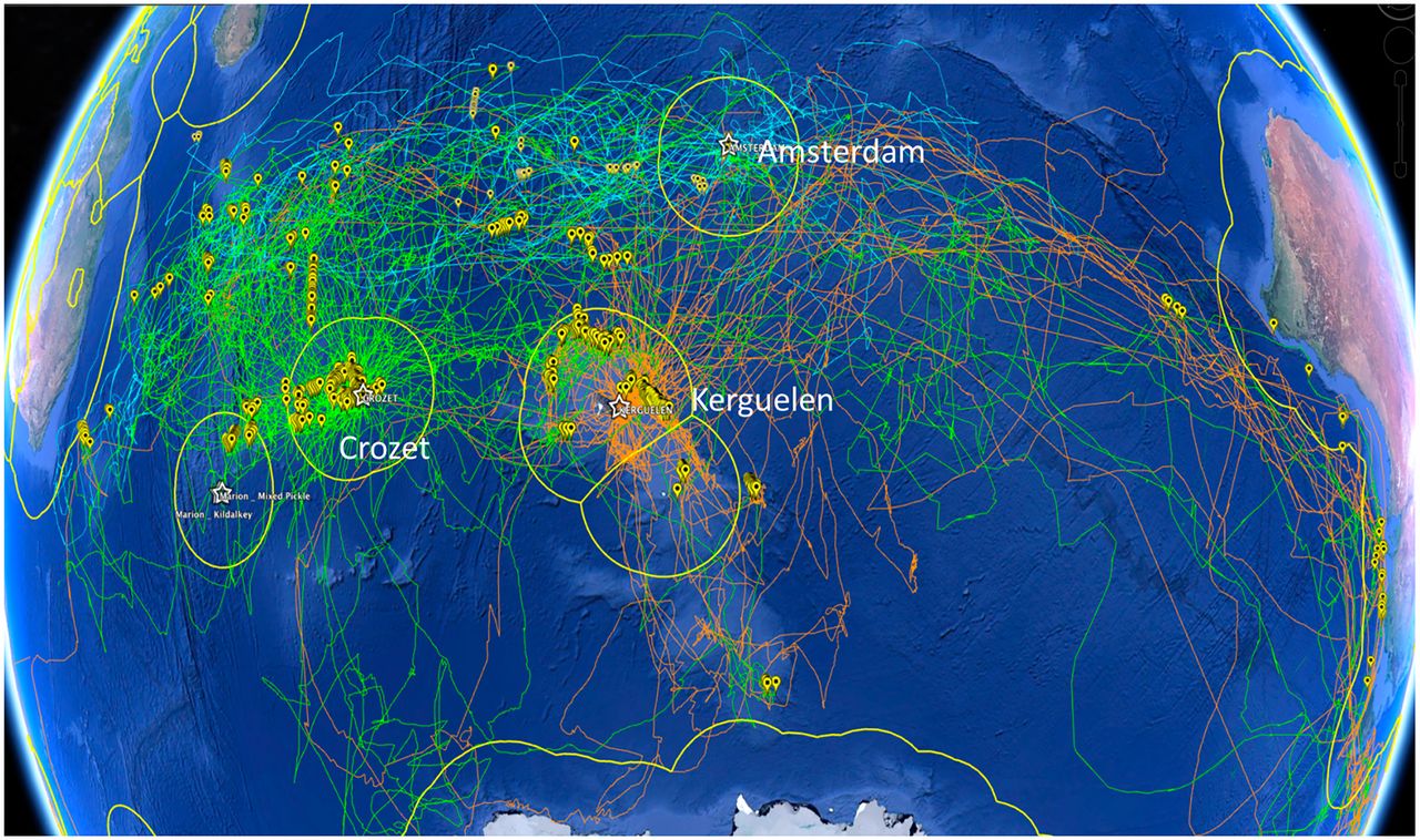
Southern Indian Ocean with the tracks of Crozet wandering albatrosses (green), Kerguelen wandering albatrosses (orange), and Amsterdam albatrosses (blue). Yellow markers show radar detections; yellow line, the EEZ limits (credit CEBC/CNRS)
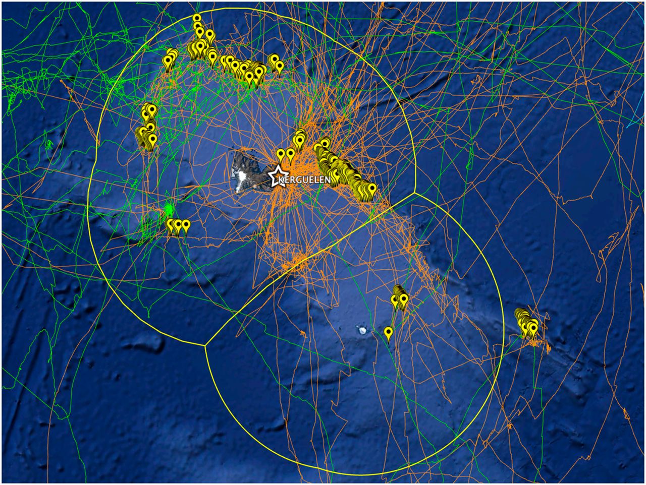
Zoom on Kerguelen EEZ zone. (credit CEBC/CNRS)
The locations of the radar detections without AIS were also compared with bathymetry and international or EEZ waters. It appeared that slightly more than 28% of the radar detections were not accompanied by an AIS emission within 30 km, with a difference between international and EEZ waters: considerably more AIS were off in international waters (nearly 37 %) than in the EEZs. Within those, however, local authorities can decide to prosecute the illegal fishing.
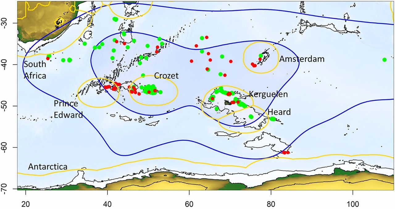
Location of radar detection with AIS associated (green dots) and no AIS associated (red dots). blue line; kernel 90% of all birds, blue zone; kernel 50%, limits of EEZs yellow line. (credit CEBC/CNRS)
The first results of this Ocean Sentinel program clearly show that animals can improve our surveillance capacity in very isolated oceanic sectors. The test was made on albatrosses, but can be replicated in other situations where large-enough, far-ranging seabirds are attracted by fishing boats.
Reference & links
- Weimerskirch, J. Collet, A. Corbeau, A. Pajot, F. Hoarau, C. Marteau, D. Filippi, S.C. Patrick, 2020 : Ocean sentinel albatrosses locate illegal vessels and provide the first estimate of the extent of nondeclared fishing, Proc. Natl. Acad. Sci. U.S.A., 117 (6) 3006-3014; https://doi.org/10.1073/pnas.1915499117
- https://www.youtube.com/watch?v=ZWAJrYwYeh0
- https://www.cnrs.fr/index.php/en/how-widespread-illegal-fishing-albatrosses-are-helping-us-answe